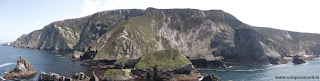
Sitting off the north coast of the south west corner of County Donegal in one of the most remote and sparsely populated areas of Ireland lives a collection of sea stacks and mini islands. This archipelago is collectively known as the Enchanted Islands and living at the base of the 300 meter high north face of Slievetooey and at a shade over 300 meters out to sea, these islands reside in one of the most remote, unspoilt and beautiful locations in Ireland.


Slievetooey North Face


Pyramid Stack Film 2013
It was on the 29th of June 2010 I went for my first wee visit to this remote outcrop as I had a very strong suspicion that the highest point of this archipelago was still at that time unclimbed. As it was a very early morning start on a mid week day I could not persuade anyone to join me on this wee adventure into the then unknown. This was a successful ascent of the largest sea stack's highest point but not without a moment of mild concern as the wee dingy was visited by a family of intrigued bull seals.
Pyramid Stack Severe 160m
Grid reference G583920 This twin headed stack was first climbed as an East to West traverse(& return) Access is by a 5 KM cliff top walk from An Port, followed by a 300 meter steep grass descent and a 300 meter paddle around the grassy island which sits between the highest stack and mainland Donegal. It's location is mind blowing and is prone to massive seas. This is a very serious stack.
I. Miller 29/06/10


Slievetooey North Face

View from the clifftops

Looking from "The Unforgiving" Sea Stack
Fast forward three years and a return visit to Pyramid Stack was made on 26th June 2013 with Andy Cronin during a spell of outrageously hot sunny weather and flat calm seas. We descended to sea level and paddled out from the same launch point as was used in 2010. We were joined by the same family of seals on the paddle to and from the stack. There was no sign of the great Skua which lived in the descent gully in 2010 and also gone were the dozen or so Fulmar nesting pairs on the west end of the main island. It may be my imagination but there seems to be a great deal less sea birds living on the western freeboard of Ireland than 5 years ago.

When the sun shines there are few places on earth that can compare to the natural unaltered beauty found on this stretch of coastline in South West Donegal. What this coastline provides for the perhaps more adventurous rock climber is the largest collection of adventure climbs and sea stack routes in such a small geographical area on earth. With Cnoc na Mara and An Bhuideal as equals in their adventurous status as the better known Scottish Cousins, The Old Man of Hoy and Stoer.

View from the summit of Pyramid Stack


